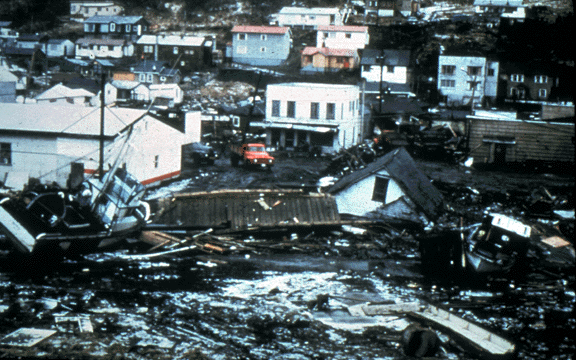
As someone who has spent my entire life on the coast of British Columbia, I feel fortunate in saying that I have never experienced a tsunami. Not one. Of course, I've seen many tsunami watches and even warnings over the years. In fact one of my earliest memories is of my parents waking me up very early one morning at Kanis Island, just off the west coast of Vancouver Island, to get to higher ground as a tsunami was apparently on its way. The allotted time passed, the water remained flat and everyone went back to bed. The same scenario has played out over half a dozen times on this coast that I can remember.
Of course, there is always the danger that a wave will materialize as it did in 1964. At 9.2 on the Richter Scale, the largest quake ever recorded in North America hit Prince William Sound on March 27th, and generated a series of wave that swept down the Pacific Coast. These surged into Alberni Inlet on the West Coast of Vancouver Island, where they grew to a hight of six meters and washed away almost 400 homes. Fortunately, the first wave was smaller and residents had a chance to evacuate before the next one arrived. Other small communities were damaged, such as Zeballos, but there no one was killed.
That was well before my time. But as I followed the aftermath of the catastrophic tsunami in Japan, and waited (albeit dubiously) for a wave to materialize on the BC coast, I couldn't help but think what would happen if a wave of any magnitude were to make it across the Pacific. This has happened once to my knowledge, and that was over three hundred years ago. In 1700, a tsunami flooded fields and washed away houses in Japan without any preceding earthquake. It wasn't until a few years ago that geologists put together written accounts from Japan with sediment and tree-ring data in North America to trace the origin of this 'orphan tsunami' to the west coast of North America. The results of this trans-Pacific detective story were compiled in an entirely readable US Geological Survey publication which is available online.
Back in the 21st century, we now have have detailed animations of tsunamis (like the one below, first seen on blogfish), to show us how they propagate half way across the world.
We also have access to satellite maps of the earthquake locations and magnitude within hours of the quake. So the next time a tsunami makes it all the way across the Pacific, we'll know about it long in advance. Maybe not so much if the 'big one' hits on our doorstep, as it did in Japan this morning.
Time to go through the emergency supplies? I think so!


Your image isn't showing up.
ReplyDeleteTofino rung all the lights at two am when it went from watch to advisory. I made sure everyone in the area knew, then went back to bed.
There really wasn't any way to tell if we got hit or not as we had a moderate swell.