Thursday, December 17, 2015

Front falls off Fraser Institute tanker argument

In a November 24th opinion piece in the Vancouver Sun, Taylor Jackson and Kenneth Green ask: Ban on oil tankers? What happened to evidence-based policy? I’d love to take them out for a little boat ride from Kitimat through Dixon Entrance some time this month, for a reality check on their views on the science behind the North Coast tanker ban. Only a dedicated policy analyst sitting in the warm, dry confines of the Fraser Institute could have come up with the reality-starved thesis that there is no scientific rationale for banning tankers on B.C.’s North and Central Coast.

I remind readers that tankers were banned from this area following the Exxon Valdez spill in 1989 and that ban, although not legislated, has been in continuous effect since that date. Put simply, we’ve had no oil tanker spills because we’ve had no oil tankers plying these waters. Traffic between Alaska and the Lower 48 states observes not only the ban, but an additional Voluntary Tanker Exclusion Zone off the West Coast, designed to ensure that when the tankers lose power or steerage, they cannot be driven onto rocky shores by wind and waves.
A December excursion through Hecate Strait and Dixon Entrance could be really enlightening for Taylor and Ken. December is the month most likely to see storm-force winds that can build in a matter of hours from nothing to 60 knots or more—which is to say, the wind can come up on a ship that has left port 18 hours earlier in fair weather, leaving it exposed and without a place of refuge.

Those winds often build the seas to heights of 18-20 metres—that’s about a six-storey building’s worth of water crashing down on the decks. The highest waves recorded in Hecate Strait are over 30 metres: more like a 10-storey building. In places along the proposed North Coast tanker route, there are also strong currents and when the wind meets a current going the other way, things get to be what mariners call “chaotic.” It’s a little different from the chaos at the Fraser Institute when a Liberal government gets elected. Things get broken.

Some of the things that could get broken in such seas are the thousands upon thousands of welds that hold double-hulled oil tankers together. A few tankers have gone that way, flexing in nasty seas until they just gave up; the ships broke into pieces and sank, spilling much of their cargo in the process. In 2010, 20 years after that particular design weakness was immortalized by the comedy team Clarke and Dawe in their sketch “The Front Fell Off”, the International Maritime Organization’s working group on oil tanker design came up with “goal based design criteria” to apply to tankers built after July 1, 2016: basically, an agreement that tankers ought to be designed such that their fronts won’t fall off. It is estimated that there are some 2,400 oil tankers in service that predate this breakthrough agreement.

In addition to the sciences behind meteorology and naval architecture, there’s also biology arguing in favour of a tanker ban on the North Coast: large ships are noisy beasts under normal operating conditions and the underwater acoustic disturbance is harmful to whales and other marine mammals. Six species of whales that are listed under the Species at Risk Act frequent the North and Central Coast. To the extent that the Canadian government has proceeded with recovery plans for them, those plans identify acoustic disturbance and ship strikes as threats to the species’ recovery. Adding ship traffic to this region, accidents or not, is bad news for whales.

Against these real-world considerations of navigation on the North and Central Coast, Fraser Institute policy analysts reference only global tanker safety statistics that are conspicuously not derived from traffic on our B.C. coast. I agree entirely with their assertion that tanker safety has improved over the past 30 years with the development of new technology. What I contest is the suggestion that this means oil tankers may safely ply all waters on the globe.

Monday, September 28, 2015

Clear the Coast 2015

By Karen Wristen

Living Oceans’ 2015 efforts to Clear the Coast of marine debris brought in an amazing five metric tonnes of debris, mainly composed of plastics of Japanese origin. Last year, working on the same Cape Scott beaches, we picked up 2.67 tonnes of plastic from all over the world, with Japanese-labelled items comprising about one-third of the total.


In an effort to put a dent in the enormous volume of plastic waste that is washing up on northern Vancouver Island shores, this year we intensified our efforts with more volunteers on the ground and more ground covered. We organized two major expeditions: the first returned to Sea Otter Cove aboard Paul Ross’s Samphire, and the second ventured into new territory for us in the Scott Islands, from a base camp in San Josef Bay.

Sea Otter Cove, August 17-24

It was delightful to return to Sea Otter Cove—it is such a pretty and secure cove and the weather was full-on summer. Sea otters plied the water daily for food, seemingly undisturbed by our presence; and while wolves and bears were evident, they kept out of sight. Dozens of different birds soared all around us as we worked. The kelp beds at the entrance to the Cove look as healthy and abundant as ever.
A raft of sea otters. Photo: Kari Watkins

Most of our crew camped on shore this year, while I stayed on Samphire to be on hand to get meals for everyone. It was quite the trick, feeding such a large crew from a tiny galley but we worked it in shifts and our volunteers were either very polite or actually impressed by the quality of the food we were able to turn out.

I’d like to say we found Sea Otter Cove clean, after all the work we did last year, but not so: we managed to fill five lift bags with nearly one tonne of debris! We recovered fishnet entangled in hundreds of metres of line that was painstakingly untangled to create bags for lifting large and unwieldy chunks of plastic, while purchased bags made of re-purposed fishnets and others designed specifically for helicopter lifts were used for most of the debris.

We hiked an easy 40-minute trail north over to Lowrie Bay on two days, because there was just so much debris there. Lowrie is a beautiful, deep sandy beach that is wide open to the Pacific, with rocky outcrops on which the waves break dramatically—a surfer’s paradise. It’s also so long that we had to establish two consolidation sites: some of the debris there was far too heavy to move long distances. Large, dense plastic pallets and the ever-present net balls are really challenging to move over soft sand! We packaged everything ready for lifting and left it high above the high tide line.
Fish floats wrapped in re-purposed fish net on the beach at Lowrie Bay.
To the south, the outer beaches of San Josef Bay that can’t be accessed from the Cape Scott trail head were easy to get to from Sea Otter Cove. A marked trail crosses level ground and not 15 minutes’ walking brings you out to the Bay. Last year, a passing family of boaters cleared a stretch of this beach for us and we picked up the debris. This year, you’d be hard-pressed to know it had ever been cleaned: I actually lost count of the number of bags we filled there, and there were multiple strings of fishing floats, tires, plastic jugs and the like that weren’t bagged, but just lifted on a rope.
Clear the Coast volunteers with fishing floats collected from San Josef Bay.


The beach at San Jo was so heavily covered in logs that it was tricky to find an area to consolidate everything for the lift—we either had to carry everything over the pickup-sticks pileup or chance leaving it where the highest tides might still reach. We opted for the latter, but I won’t do that again: when we came back to get it at the end of the next expedition, it was half-buried in a load of seaweed and sand and getting it out was a dirty, smelly proposition!

I missed the voyage to and from Sea Otter on Samphire, as I’d elected to drive to San Jo so that we’d have a vehicle in case of emergency. Our science volunteer, Garth Covernton, accompanied me and so the pair of us had to be shuttled around to San Jo’s inner beach to hike out to the truck. Paul Ross had nearly flipped his inflatable in the surf the day he came to pick us up, so we were cautious about a drop-off point. We chose to land at the second beach, knowing nothing about the trail between there and the trail head. Let’s just say I was not inclined to argue with B.C. Parks’ characterization of it as “treacherous” when I later read the sign at the trail head!

It’s a bone-jarring ride on a logging road from the Cape Scott trail head back to Port Hardy and it’s wise to keep one’s fluids up by stopping at the Scarlet Ibis in Holberg along the way. Legendary fish and chips and the first cold beer to be found outside the Park.

Lanz and Cox Island Provincial Park, September 5-8

Our second expedition was planned to attack the innermost of the Scott Islands group. Last year, our helicopter pilot had told us that the islands were choked with debris and she was right! This trip had to be done by helicopter because the waters are so dangerous and we needed large numbers of volunteers to do the work in a single day—or so we thought.
Karen Wristen among the jagged rocks on the beach at Cox Island.

We established a base camp on the beach at San Jo Bay, with 18 of us in tents and a cook tent rigged up over a helpfully large root ball buried in the sand. I have to mention the 45-minute trail down which we’d had to bring enough food and supplies for 18 people for four days—my partner Jasper and I using wheelbarrow and dolly, and volunteer Michael Neate using his bicycle trailer sans bicycle (they’re not allowed in the park) barely managed it. Sure, it’s wheelchair accessible; it’s also one of those trails that gets longer and hillier every time you do it!

We hired West Coast Helicopters to take us out to the Island in teams of four or five people per beach. We’d hoped to be able to hop from beach to beach and do a couple each, but found so much debris that we could have spent more than the hours we had just cleaning the three we chose to start with. We also found that, at low tide and in calm weather, there would have been no problem camping overnight on at least two of the beaches, so we could have planned a more extended cleanup.

I worked with Terry and Eric Grantner and Michael Neate on the first beach on which we landed a crew. Within three hours, we had bagged up four lift bags, one net bag and a huge string of floats. The helicopter returned with its hook on and removed our bags in two lifts. At this point, Mother Nature began interfering with our plans. When the helicopter returned, there was no hook in sight and we knew something was wrong. We climbed aboard and learned from our pilot, Paul Smith, that the weather was closing in fast and worse—he’d found his spare fuel contaminated with water. Facing two uncertainties, he’d elected to get the crews out as fast as possible. Looking at the ugly, dark cloud closing in from the north as we headed back to San Jo, I was happy for his good judgment!

Unfortunately, we’d been unable to communicate with one another on the VHF radios we’d brought—the headlands between the beaches were too much of a barrier. Each crew could communicate with the helicopter when it was within range, but that didn’t give the other two crews enough warning to be able to secure their bags to shore to await a later pickup. We were all concerned that a high tide would float them out, posing a hazard to navigation and to wildlife that might become entangled in the ropes securing the bags to one another. We waited uneasily through a drizzly night to find out what the morning would bring.

The next day must have dawned—the fog got brighter, at least—and I was certainly not expecting the helicopter that landed about 10:30 with the news that we could try to lift out some of the bags from the first expedition. Lanz and Cox were out of the question, however; a blank wall of sea fog obscured them from view.

Jodie, Michael and I were off to tend the lifts within minutes. We managed to get everything out of San Jo and all but one bag from Sea Otter before the pilot had to leave for another job. That left the Lowrie, Sea Otter and Cox Island loads stranded; we were out of budget and out of time with this crew of volunteers.

I have to break the continuity here to recall some acts of exceptional heroism. One of the net bags that left Sea Otter Cove looked like trouble from the minute it left the beach—the load of irregularly shaped plastics had become hung up in the net and wasn’t sitting in the bottom of it the way it should. That would place undue stress on the net and I feared it would tear. It didn’t; but what did happen was that the load fell into the bottom of the net and snapped the rope from which it was hanging just as the helicopter passed over our campsite!

Taking nothing away from the effort that everyone put into this expedition, I have to say that Marten Sims deserves special mention for getting into the water in San Jo Bay on a cool September day to attach a line to the bag. Nigel Marshall, too; when the line Marten was carrying proved too short for the job, he waded in behind Marten and between them, they recovered the bag intact. He, Wesley Piatocka and Cassy Bergeron packed the load out to the bins at the trailhead using the wheelbarrow and trailer, in two trips that left them exhausted. Kudos to them and to everyone who helped plan the recovery, warm up the swimmers and break down the load for packing out!

We packed up camp on the morning of September 8th. Returning to Sointula, I called Coast Guard to report a potential hazard to navigation, put out an urgent call for funding and a media release and began appealing to the public for help. And that’s where the amazing things started happening...

The Third Expedition

First, the Vancouver Aquarium called to say they had a little bit of tsunami debris funding left and they could help. On the strength of that and some generous donations from our supporters, I booked a helicopter and debris bins for the weekend of Sept 19th and 20th. Michael Neate and Jodie Bergeron volunteered to join me, as we expected to find our bags scattered by the tides and needing some man-handling to get them into position for lifting.

Just before I left, the Canadian Wildlife Service called to say they could purchase some helicopter time for us. And while I was up island waiting on the weather (again), the Cape Scott Wind farm called to say they would donate two hours’ of helicopter time. And then the sun came out, against all predictions.

We still ended up having to do the work over two days, when Saturday dawned quite soggy. The ceiling was high enough despite the rain, so we flew from West Coast’s Port McNeill base to our first stop near Hanson’s Lagoon, where I’d agreed to look for the kit of a shipwrecked sailor who had contacted me that week. He’d provided co-ordinates, so it took no time to locate the wreck and salvage his dry bags. The wreckage was too large to contemplate moving, so we stowed it above the high tide line.
Shipwrecked sailboat near Hanson's Lagoon.

From there, we hooked up the bags at Lowrie Bay with no difficulty. The helicopter was a while coming back, though; and when it did, our pilot said the ceiling was lowering and so he’d hooked up the load at Sea Otter himself and dropped it; we were heading home. It was the lowest flying I ever hope to do, but very instructive: we were able to take a good, close look at all the pocket beaches south of Cape Scott and every one is full of debris!

Sunday, the weather forecast changed dramatically and we were off—driving to San Jo Bay one more time. The pilot needed to sling fuel out to San Jo in order to be sure of having enough for the job, so we could not fly with him. We arranged to meet at the San Jo parking lot—if we were needed. Mike Aldersey, the base manager, was flying this job himself and he felt it would be most efficient if he went out alone and did the hookup. We were there as backup, if it proved we were needed to move the bags about.

It did turn out that we were needed—after the first load, Mike landed to explain he had to have someone on the ground to help with the rest. But his helicopter was showing a warning light and we’d have to wait for another one from McNeill. That meant another pilot, who could be with Mike in the helicopter while they flew a load in—something he can’t legally do with passengers. We had to decide between doing two trips—one for passengers and one for debris—or letting them handle it themselves. Naturally we opted for the most efficient approach, although not without regret that we wouldn’t see Cox Island again this year.
Marine debris in a bin.


We stayed to see two more 30-yard bins filled with the remaining debris, making four in total that we’d recovered. To give you an idea of the volume that represents, I figure I could park two of my Honda Civics in a bin lengthwise, and open the doors right up without touching the sides. They’re about eight feet tall. Stacked two and two, they’d be about the size of a small two-storey house. It’s amazing to think we recovered that much with the work of about 20 people over seven collection days; more amazing still to realize that there is easily 20 times that much still out there on Cox, Lanz and Vancouver Islands.

Jodie Bergeron, Michael Neate, Ross Weaver and I sorted that last load for recyclables at the 7-Mile Landfill the next day. Thanks to the Regional District of Mount Waddington, we were not required to pay the tipping fees and received an accurate, weigh-scale total for our labours.

Tuesday, June 9, 2015

Salmon in the Kitchen

If you love eating salmon but aren’t too sure about preparing it yourself, then you should sign up for the Salmon in the Kitchen workshops that Living Oceans is hosting this summer in Vancouver. You’ll get a hands-on opportunity to cook, fillet and can fresh salmon under the guidance of expert chefs. Included in the cost of each workshop are the salmon supplied by Skipper Otto's Community Supported Fishery delivered fresh off the boat right into downtown Vancouver. You get to take the filleted/cooked/canned fish home with you.

Learning to fillet salmon.
Learning to fillet salmon. Photo: Sonia Strobel

Workshop details

Register online for the workshops
Cooking
A hands-on workshop that covers the basics and foundations of how to cook with salmon. Recipes will be different for each workshop. The workshop will include tastings for all participants and attendees will be sent home with copies of the recipes.
Maximum 8 participants per workshop. $52* per person per class.
  • Tuesday, Aug. 18, 6:00 – 9:00 pm at Save On Meats, 43 W. Hastings St., Vancouver
  • Tuesday, Sept. 15, 6:00 – 9:00 pm at Save On Meats, 43 W. Hastings St., Vancouver
Filleting
Buying whole fish is often the most economical, as long as you don’t butcher the fish! Come master your knife skills in this hands-on workshop where you will get to fillet your own fish and vacuum seal it to bring it home.
Maximum 8 participants per workshop. $57* per person per class.
  • Thursday, June 25, 6:00 – 8:00 pm at Save On Meats, 43 W. Hastings St., Vancouver
  • Thursday, July 16, 6:00 – 8:00 pm Save On Meats, 43 W. Hastings St., Vancouver
Canning
Canning salmon is one of the best ways to preserve the ocean’s bounty for the winter months and this demo-style workshop will teach you all the tricks of using a pressure canner. Workshop participants will take home a step-by-step salmon canning guide and a small jar of canned salmon.
Maximum 12 participants per workshop. $32* per person per class.
  • Tuesday, Sept. 29, 6:00 – 8:00 pm at Save On Meats, 43 W. Hastings St., Vancouver
SmokingThere will also be two salmon smoking demo-style workshops in the fall. Details coming soon.
*$2 from the registration fee will go towards supporting ‘train-the-trainer’ workshops at local community kitchen spaces to help increase cooking skills and capacity in vulnerable populations.

Skipper Otto’s first started teaching people how to prepare salmon at Fisherman’s Wharf at Granville Island in Vancouver. Year after year the workshops have grown in popularity as people get more interested in eating locally and preparing their own gourmet meals. This year, they’re being held at the Save On Meats Community Kitchen at 43 W. Hastings.

Doris Gnandt and Serena Chu will be the chefs guiding the workshop with Doris handling the cooking and filleting and Serena taking care of the canning sessions.
Doris GnandtSerena Chu
Doris Gnandt (left) believes you should cook from the heart and it shows in her filleting and cooking demos. Serena Chu (right) likes to make things that are irresistibly tasty but actually healthy!


Skipper Otto’s filleter extraordinaire Rumi Hokubay practices the traditional Japanese method of filleting called San-Mai Ni Orosu. Participants in the Filleting Salmon workshops will get to fillet their own fish, vacuum seal it and bring it home!

The Salmon in the Kitchen workshop series creates community around—and awareness of—our local fisheries. Most of the fresh, local, sustainable fish caught by fishermen on the South Coast is exported or sent directly to high-end restaurants. As a result, over 80% of the seafood bought in Vancouver is imported. By teaching people the skills and knowledge about local seafood and how to handle it, we increase the value of the fishery to the local community. This in turn makes the local seafood supply chain more resilient and lends to increased food security in our community.

The workshops aren’t all work though. There’s a lot of fun involved too. And food. If you attend the Cooking with Salmon workshop don’t eat a big dinner beforehand, as you’ll need a good appetite to taste the recipes you’ll be cooking.

canned salmon
At the Canning with Salmon workshop participants will learn the basics of how to use a pressure canner, receive a step-by-step guide to reference later, and be able to take home one jar of canned salmon. Photo: Wendy Davis

We are grateful to our local partners and sponsor – Skipper Otto’s Community Supported Fishery, Save on Meats, Vancity enviroFund, and the Vancouver Foundation Greenest City Fund.

Sunday, June 7, 2015

Take a deep breath, take pride and then take action

By Karin Bodtker

Today, on Oceans Day, I invite you to think about your connection to the ocean. Everyone has a connection to the ocean. For me the ocean is deep—in more ways that one! When I was in my early twenties and lived close to beach, a solo walk along the seashore would allow me to revel in my emotions—which were dynamic, intense, pushing and pulling me one way and another. Perhaps the action of the waves soaked up some of the intensity (as I said, I was in my early twenties) and I felt able to carry on.

These days I think my connection has a much more scientific edge to it (this is safer territory). I know that Canada’s ocean ‘estate’ is roughly 70% as big as its land-based estate. As Canadians, we can certainly be proud of the magnitude of our oceans and the awe inspiring seascapes that surround our country. No matter where we live in Canada, rivers and waterways connect all our homes to one of Canada’s three oceans.

Now take a deep breath and say a word of thanks to the ocean. Every other breath you take comes from the ocean because the oceans’ plants produce half of the world’s oxygen. That’s a pretty necessary connection for all of us. How do we ensure this connection persists and our oceans stay healthy? One way is through Marine Protected Areas (MPAs). MPAs are ocean places that are set aside like parks, providing sanctuary for individual species and entire food-webs so they can recover and thrive. They’re like an insurance policy. Take a moment to tour a few protected areas (one in each province) that showcase some of Canada’s spectacular wildlife and connect us to the oceans. Revel in the beauty, feel the pride; after all, it’s Oceans Day!
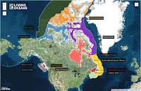
Connecting Canadians is our new interactive map that shows how the ocean touches every province and territory in Canada. Healthy oceans matter in Eyebrow, Saskatchewan... and everywhere else in Canada, too!


Currently, only 3.4% of the global ocean is in protected areas, compared to 15.4% of the world’s terrestrial and inland water areas. However, it’s higher (8.4%) if you consider only marine areas within national jurisdiction (e.g., exclusive economic zones)1. When we look at Canada’s record, we get a bit of a shock – less than 1% of Canada’s oceans are protected. Still proud of Canada? Browse through our new maps to see all the MPAs or check the protection status for each of Canada’s 12 marine bioregions.

http://www.livingoceans.org/maps/how-protected-are-canadas-oceans http://www.livingoceans.org/maps/canadas-marine-bioregions-protection-status-2015


What about connections between protected areas? That’s the way to really make protected areas efficient; build a network. In 2011, Canada released a National Framework for Canada's Network of Marine Protected Areas, a document to guide design of networks of MPAs. That was four years ago, and guess where all the newly designed networks are? Nowhere. That’s right, no networks completed yet. Where’s your sense of pride now?

A few days ago, Living Oceans along with five other conservation organizations, delivered a set of MPA recommendations to every single Member of our Parliament. We are urging the federal government to step up the pace on marine protection. This Oceans Day, please take action and add your name to the list of those who support a more robust insurance policy for our oceans.


1. These stats come from the Protected Planet Report of 2014 from the United Nations Environment Programme World Conservation Monitoring Centre (UNEP-WCMC), so I trust them.

Tuesday, April 14, 2015

English Bay Oil Spill Response is Instructive

The grain freighter Marathassa at anchor in English Bay, surrounded by a boom the day after it leaked an estimated 2,700 litres of bunker fuel into the ocean.
If you ever wondered what the federal government really meant by “World Class” oil spill response, now you know. The English Bay spill on April 8 proved out a lot of the criticisms that Living Oceans has been making about spill preparedness in B.C, yet to listen to federal government pronouncements, you’d think the response was perfection itself. This, then, is a world class spill response.

The Coast Guard has spared no effort to praise its own efforts and those of Western Canada Marine Response Corporation, the oil-company owned outfit contracted to pick up the oil. Commissioner Jody Thomas in “enormously pleased”; Assistant Commissioner Roger Girouard says the response was by the book and advised the CBC on April 11 that only about six litres of oil remained in English Bay. Girouard maintained that 80% of the oil had been cleaned up by skimmers working the water’s surface. "You don't contain 80 per cent of a spill inside 36 hours and call that inadequate," he said. "I will not accept that definition of my team."

On the response time, Commissioner Thomas was very specific: "Within 25 minutes of notification, we were on the water. And with [Western Canada Marine Response Corporation], we worked through the night to skim the water and boom the ship."

The only statement above that is entirely correct and complete is that the response was by the book, which is to say that the WCMRC was on the scene with recovery equipment within the time prescribed by Transport Canada. From the handbook: “[I]n Port Metro Vancouver it is required that WCMRC maintain a dedicated package of equipment that is capable of responding to a 150 tonne spill within 6 hours.” The fact that they didn’t actually deploy their booms until somewhere between midnight and 2:00 a.m. takes them a little outside that response time, but hey, they couldn’t figure out where the oil was coming from.

Clearly, a textbook spill response will result in the oiling of Vancouver’s beaches, as it has here. This was said to be a two-tonne spill (2700 litres); Kinder Morgan’s idea of a “credible worst case” spill is 10,000 tonnes, just to put the question of beach oiling in perspective.

But what about the size of the spill and the “80% cleanup”? By April 13, Coast Guard was admitting that the spill size estimate they were using was a conservative estimate made by flying over the area to determine the spill’s visible dimensions and multiplying that by estimated spill thickness. That sounds quite reasonable, unless you knew from the time of the initial report at 5:05 p.m. on Wednesday that much of the oil was already under water and thus invisible from the air.

Rob O’Dea, a sailor who reported the spill, said, “… it was an oil slick about ½ km long and 250 m wide. The surface was covered with a blue sheen and just beneath the surface there were globules of oil by the thousands per square metre. They were within the top few inches of the water… Some were the size of a pea, many were the size of a fist.”

And where was it coming from? Rob apparently had no difficulty figuring that out: “When we passed by the stern of the offending freighter there were larger, sticky globs of black goo a meter long and as thick as your arm. Oil was everywhere at and below the surface. The crew of the ship were madly trying to load 50 gallon drums from a small boat onto the ship while at the same time they were dropping small pails over the side of the ship and hauling up water. It was a keystone cops kind of scene and the Port Metro boat passed by in close proximity but did not intervene.” (That Port Metro boat is apparently the one that “we” had on the water “within 25 minutes”; Rob says it showed up about 6 pm. WCMRC wasn’t there at 8 pm when he decided to go in.)

Unconfined oil will spread to a thickness of about 0.4 mm. Sticky globs of black goo a metre long and as thick as your arm don’t. Yet there was Girouard, insisting that “physics tells us that it will float” (a direct quote, by the way, from one of Enbridge’s experts at the hearings on the Northern Gateway Pipeline hearings) and reporting on the reductions in surface oil as if it were all that required response.

The truth is that nobody will ever accurately estimate how much oil spilled, given that within a very short time after the spill, so much of it submerged beneath the water’s surface. The water in English Bay right now will be low in salinity and high in suspended particles because of the plume coming out of the Fraser River and those are the ideal conditions for sinking the oil into the water column, perhaps even to the bottom. We may be finding tarballs from this spill washing ashore for years to come.

As recently as two years ago, Coast Guard had a dedicated spill response vessel and a trained crew at the [former] Kitsilano base who, according to retired Coast Guard Capt. Tony Toxopeus, could have responded within an hour and perhaps contained the surface spill before it hit the beaches. “They’re downplaying it to such a degree it’s shameful, it’s terrible, it’s dishonest,” Toxopeus said.

“There was a 40-foot boat that was purpose built for oil pollution response,” said Toxopeus, adding the base also had 150 metres of Kepner self-inflating boom, 150 metres of 24-inch fence boom, 30 metres of oil absorbant boom, a skimmer and absorbant pads. “That was probably the best equipped station on the B.C. coast.”

Even that equipment would have been inadequate to respond to submerged oil, which could pass under the floating booms and travel with the current. Note that this was bunker C oil, carried by nearly every vessel in the Port. It’s much like the bitumen that Kinder Morgan wants to ship—a heavy oil, given to forming dense, sticky mats and globs, rather than just spreading on the surface.

In summary, “World Class” oil spill response apparently means critically disabling the ability of Coast Guard to respond to spills in the harbour of the B.C. city most liable to experience an oil spill and denying that you did so; handing the task over to a corporation owned by the oil companies themselves; and legislating response times that are clearly inadequate to protect the Greenest City from beach oiling. Add in the power of the federal government’s communications machine to spin the facts—80% recovery, 25 minutes to have “a boat in the water” and “physics tells us it will float”—and repeat ad nauseum that you’re doing an excellent job.

I don’t buy it and judging by the public response, neither do most in Vancouver.

Friday, March 13, 2015

MPAs Work Together for Healthy Oceans and Communities

Canada is part of a global effort to ensure that at least 10% of our oceans are in marine protected areas (MPAs) by 2020, but we currently only protect 1.3% of our total ocean estate. MPAs are management areas that are put in place to protect species, habitat, and heritage sites—like the Great Barrier Reef Marine Park in Australia. They are a designated place in the ocean where human activities are regulated and restricted to reduce our impact on the ocean and coastline.

MPAs can have different designs, protection levels and management structures. The most effective ocean conservation areas around the world have high human use restrictions but the level of use in them can vary. For example, one MPA may not allow any human entry at all, while another may allow ecotourism activities like kayaking and diving, but no extractive activities such as fishing. In order for these regulations to work, there must be effective enforcement of the rules by authority figures like park wardens or fisheries officers. MPAs should ideally be large in size, but sizes may vary depending on which habitat or animal is in need of protection. Research has shown that the most successful MPAs have been established for a long time, since it can take decades for animals and habitats to reproduce and thrive. They also tend to do best when set in an isolated place away from human pressures and conflicts. Understandably, some MPAs can’t have all of these features but we must aim for as many as possible in order to effectively protect the marine environment. When successful MPAs are put in place, they conserve our oceans and help maintain and improve the coastal economies that rely on them.


A couple of great examples of MPAs in British Columbia are the Endeavour Hydrothermal Vents Marine Protected Area and the Gwaii Haanas National Marine Conservation Area Reserve & Haida Heritage Site. It’s wonderful that B.C. has some marine protected areas but it’s not enough. Currently less than 3% of B.C.’s marine environment is protected. We need more parks. In fact, we need an entire network of MPAs.

Recently, the federal government released the Canada – British Columbia Marine Protected Area Network Strategy which provides guidance for the design of marine protected areas along the Pacific coast, and is a step towards increasing Canada’s current level of marine protection. A network of MPAs is a collection of different sized parks with various levels of protection that are spaced close enough to one another to allow marine species to move between them. Studies from around the world have shown that networks of ocean parks can provide benefits to entire marine ecosystems while also balancing important social, economic and cultural human needs.


Not only would the entire Pacific marine ecosystem off the coast of B.C. benefit from a network of MPAs but so would the coastal communities that rely on the ocean. Benefits would include more local and sustainable jobs on the coast, better food security, protection of recreational, heritage and traditional sites, as well as increased ocean conservation and education about the marine environment.

Although the federal government has released an MPA network strategy for B.C., we need to see movement towards establishing these parks. The province and participating First Nations are already on their way to releasing and implementing marine plans for part of the B.C. coast, through the co-lead Marine Planning Partnership for the North Pacific Coast (MaPP) planning process. Set to be released later this spring, these marine plans are a solid basis for the Canadian government to work off of to begin establishing a network of federal MPAs in B.C. Taking the research and recommended marine protection areas from the MaPP plans and enhancing them to the federal level will ensure that MPAs are established to maintain and improve what is needed for healthy oceans and coastal communities and begin building a better future for our coast.

Thursday, February 19, 2015

Cohen Commission recommendations gather dust while salmon farm applications keep on coming

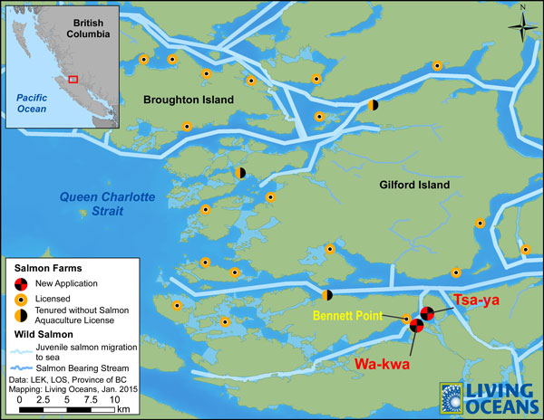
By now there must be half an inch of dust atop the Cohen Commission’s report on the plight of the Fraser River sockeye as it languishes on some forgotten bookshelf in an Ottawa backroom. How else to explain the total disregard for the commission’s findings? Surely the salmon farmers’ recollections of Justice Cohen’s recommendations have grown hazy since 2012 when the findings were released. Stewart Hawthorn, the Managing Director of Grieg Seafood BC, wrote in a letter to the Campbell River Mirror that the Cohen report “provides further evidence that salmon farming and wild salmon stocks can live well together.” Well, not quite. The government closed the Discovery Islands to increased finfish aquaculture until at least 2020 due to concerns that open net-pen salmon farms were impacting Fraser River sockeye migrating through this area.

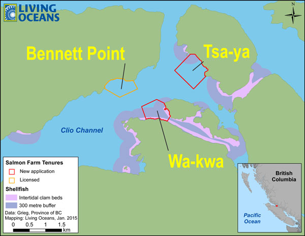
No matter. Mr. Hawthorn’s letter was an invitation to an open house his company was holding to promote two new salmon farm applications in Clio Channel in the Broughton Archipelago. The Discovery Islands are immediately south of the Broughton; the same fish pass through both areas. The letter invited readers “to come and meet our staff, ask questions and provide comments.”
Proposed site of new Grieg Seafood salmon farms.
On the afternoon of February 10th over 70 people from the small village of Sointula decided to take Mr. Hawthorn up on his offer. They got into a whale watching boat and crossed Broughton Strait to stand shoulder to shoulder in a small room in a Port McNeill hotel where Grieg Seafood was holding the open house. Also at the open house were representatives from Fisheries and Oceans Canada (DFO), and the British Columbia government. I wouldn’t go so far as to say things got out of hand, but the Sointulians were not pleased about the idea of Grieg cramming about one million farmed salmon into 26 net-cages, each measuring three by 30 metres, into a channel less than 1.5 km wide that serves as a migration route for wild salmon smolts heading to the ocean.
The Grieg Seafood open house in Port McNeill was well attended by coastal residents opposed to more open net-cage salmon farms.
Maybe Mr. Hawthorn’s staff weren’t expecting folks would actually show up to get a few things off their chests. But there are a lot of people in the Broughton that depend on a healthy ocean to make their living. And there are already 29 open net-cage salmon farms in the archipelago dumping feces, fish food and sea lice into the ocean. People from Sointula know what the score is and what’s at stake.

One fishermen at the meeting asked why Grieg was allowed to kill off the wild salmon for free. Another pointed out that the existing farms are essentially unregulated by DFO. Someone else pointed out that the drugs Grieg uses to kill sea lice in the farms also kill prawns and shrimp. A nearby lodge owner said that the farms are turning the area into an industrial zone. You get the idea. One woman summed the mood up nicely: “Put your damned farms on land or go back to Norway!”

Now you can weigh in too. Here’s the situation in a nutshell. Grieg Seafood want to convert two shellfish aquaculture tenures to salmon farms. No environmental impact assessment of the two new farms has been done, even though finfish farms have very different impacts from shellfish farms. This is the first time that the salmon farming industry has asked to transfer tenures from shellfish to finfish. If they are granted approval it could open the floodgates to other shellfish tenures being converted to salmon farms—and there are a lot of unused shellfish tenures on the B.C. coast right now.

The proposed salmon farms are close to intertidal shellfish beds that are exposed to water flows from the farms. These clam beds are important to First Nations and others in the area.
We have reviewed the applications and feel strongly that they should not be approved for a number of reasons including that they do not comply with the government’s own criteria:
  • The farms would be too close to salmon bearing streams, vital herring spawning areas, and shellfish beds. 
  • They are also in close proximity to not only one another but also an already established salmon farm  at Bennett Point, which could create navigational issues in Clio Channel.
DFO admits there are gaps in its knowledge regarding finfish aquaculture, such as the effects from pesticides, antifoulants, disinfectants, drugs within feces and risk of pathogen transfer to wild fish. Herring spawning in this area are vital to the rich ecosystem, supporting whales, seals, birds, fish, etc. that in turn support the economies of Sointula and other northern Vancouver Island communities with industries like wildlife viewing, kayaking, boating, diving as well as recreational and commercial fishing.

We’ve laid out our argument in an action alert on the Living Oceans web site. You’ll see links there to the B.C. government’s Ministry of Forests, Lands and Natural Resource Operations web site where you can submit your thoughts about Grieg’s new farms before February 24th. You can also send a message to Grieg from the action alert directly if you’d like to get a few things off your chest.